Arctic Sea Ice has reached a new record low maximum. The Guardian covers it quite nicely in this article.
Arctic sea ice extent hits record low for winter maximum
In writing a reply to a comment for the article I ended up listing a number of major reasons why the Arctic is under attack. It turns out there's an awful lot of mechanisms and feedbacks that are making Arctic Sea Ice increasingly vulnerable. Off the top of my head I could think of these:
1. Most of the ice is now easily melted first-year ice, which even when it melts is less likely to refreeze, because it doesn't change salinity of the top layer of water much.
2. The Arctic sea surface temperatures are rising, and will be hit harder again, now we are in an El Nino phase; so melting from below is becoming more of an issue. [This is the primary cause of this years record low Arctic Maximum]
3. The increased amount of open water in the Arctic ocean means that Arctic sea ice is being affected more by storms. In the past the ice itself dampened waves; the effects of currents and could distribute the force of storms across the ice pack. Now there are open waves and the structural integrity can't withstand the currents nor storms. One the effects of this is 'flash melting' where stunning amounts of sea ice can suddenly melt by being submerged during a storm (this was a contributory factor to the summer record in 2012).
4. The increased amount of energy in the atmosphere around the Arctic ocean means that storms are becoming more common and stronger.
5. The increased humidity above the arctic has numerous effects. (a) Water vapour is a greenhouse gas and therefore it acts as a positive feedback on melt. (b) Increased cloud cover reduces direct levels of radiation acting as a negative feedback (though it's understood less than (a)). (c) Regular air temperatures above 0ºC means that rain is increasingly likely and rain is a much more effective thermal conductor than air (because water has a much higher specific heat capacity).
6. Arctic melting is starting to reach the coasts of the Greenland and Canadian Archipelago. This means that the multi-year ice is no longer held fast to the land and is therefore more easily transported.
7. Increased outflow and calving from Arctic glaciers, particularly in Greenland adds to the destabilisation of land-fast Arctic sea ice.
8. The opening of the North East Passage and in particular open water from the North Sea to the Bering Strait (separating Alaska and Russia) means that for some of the year actual ocean currents can flow all the way across the Arctic. This, again, increases transport.
9. The increased rate of arctic temperature rises compared with more southerly latitudes means that the northern Jetstream is breaking down (this is different to the Gulf stream of course). The effect is to make the Jetstream more wavy which allows warmer air to be transported to the Arctic (often raising temperatures by >20ºC) as well as transporting cooler air further south causing major climatic problems in Canada and North America (the Polar Vortex).
So, in short - there's whole set of depressing indicators and feedbacks as the Arctic Sea Ice melts, which is why as a whole it's accelerating.
Showing posts with label Arctic Collapse. Show all posts
Showing posts with label Arctic Collapse. Show all posts
Friday, 20 March 2015
Monday, 24 June 2013
Calgary Flooding Podcast Transcript
Hi folks,
I had just finished a facebook status on India's recent 60-year flooding event (just a fortnight or so after Central Europe's multi-century flooding event) when I discovered that 70,000 had been evacuated from Calgary because of yet another flooding event.
Most media reports (but not this one) are bending over backwards to play down the the connection, but there's an awful lot of 'freak' weather, going on these days. Bob Stanford's interview on Anna Maria Tremonti's podcast about Calgary's flooding just a few days ago was a superb description of the state of play of the current state of climate science and extreme weather events.
It's so informative, I thought I should provide a transcript.
Anna Maria Tremonti: 'Well Bob Sanford lives in Canmore too, but he's in Winnipeg this morning. He's been trying to make sense of these and other severe floods and he's come to a disturbing conclusion. Bob Sanford is the chair of the Canadian Partnership Initiative of the United Nations Water For Life Decade and the author of "Cold Matters - The State and Fate of Canada's Fresh Waters." ' Good Morning!"
Bob Sanford: " Good morning Anna."
Anna: "Well, what do you make of what we're seeing across Southern Alberta this morning?"
Bob Sanford: "Well, to scientists working in the domain of climate effects on water this is, really the worst of all possible outcomes. We built on flood plains because we thought we had relatively stable climate, the climate that we've experienced over the past century. We thought it would stay the same. We also thought that we had a good grasp of how variable we could expect climatic conditions to be based on what we've experienced in the past century.
And now we've discovered that neither assumption was correct. We do not have adequate means to protect development on flood plains; climatic conditions are more variable than we thought and that variability is increasing as climate changes and we've also discovered that our hydrologic conditions are changing."
Anna: "So what do floods like this tell us about what's happening with our water cycles?"
Bob Sanford: "Well if we put all of the data together they tell us that warming temperatures are altering the form that water takes and where it goes in the hydrosphere. Evidence that increasing temperatures are accelerating the manner and rate at which water is moving through the hydrological cycle is now widely enough available to allow us to connect the dots with respect to what's happening in Canada. So let's start very briefly in the Canadian Arctic. In the North and throughout much of the Canadian Boreal, water that's been trapped as ice in the form of glaciers and as permanent snow pack and permafrost is, is in decline. And the same sort of thing is visibly evident in Canada's Western mountains. There's now evidence that we've lost as many as 300 glaciers in the Canadian Rockies alone between 1920 and 2005. And the same thing that's causing our glaciers to disappear is (in combination with landscape change) changing precipitation patterns on the great plains.
And the same warming is causing water left on the land after the last glaciation in the great lakes region to evaporate. So, you might well ask 'where's all this water going?' And one of the places it's going is into the atmosphere where it becomes available to fuel more frequent and intense extreme weather events such as the one that you had in Toronto in 2005 that cause $700m [Canadian] worth of flood damage to infrastructure, roads and homes. And you may remember that, in that year, that Calgary just dodged the same kind of bullet - well - not this time. And what we're seeing here is that rising temperatures and the increasing concentration of atmospheric vapour are making what were once predictable, natural events, much worse and what we've discovered is that the atmosphere holds about 7% more water vapour for each degree celsius temperature increase.
And what this tells us is that the old math and the old methods of flood prediction and protection won't work any more. And until we find a new way of substantiating appropriate action in the absence of this hydrologic stability, flood risks are going to be increasingly difficult to predict or to price, not just in Calgary or Canmore, but everywhere."
Anna: " So you're saying, then that there's more condensation in the air. Warm air can hang on to water longer and then - burst when it hits somewhere that can no longer hang on to it?"
Bob Sanford: "Well, warmer atmosphere is more turbulent and it carries more water vapour. And we're seeing that happening widely. We're also seeing in North America disruption in the Jet Stream which is allowing climatic events to cluster and remain in places for longer periods of time, resulting in more intensive floods and droughts. And we're seeing this as a result of the general warming in the atmosphere."
Anna: "And you've said that this is because of Climate Change. How do we know that this isn't just a fluke, an outlier?"
Bob Sanford: "Well, we know that Classius Clapeyron relation is one of the standard logarithms, or algorithms that we use in Climate Science. And we know that as the temperature increases we know what we can expect in terms of water vapour increases in the atmosphere and we're beginning to see some very interesting phenomenon associated with this. Things like atmospheric rivers. Great courses of water vapour aloft that can carry between 7 and 15 times the daily flow of the Mississippi and when these touch ground or are confronted by cooler temperatures that water precipitates out and what we see is huge storms of long duration and the potential for much greater flooding events."
Anna: "So, what you're saying is this part of a blot or pattern across North America."
Bob Sanford: "Well, unfortunately, this may be the new normal. I regret to say that everything we know about how climate affects the hydrologic cycle supports or suggests that events like this are likely to be more common. And the insurance industry has already warned us of a trend towards more intense and longer duration storms that cause more damage especially in areas of population concentration. And this is certainly what we're seeing in the Calgary Area."
Anna: "What are you hearing from people you know in Canmore?"
Bob Sanford: "Well, there's a great deal of concern about how long this event is going to last and, well we heard from residents there this morning on your show, there is a deep concern about how much damage there has been done to very expensive infrastructure, roads and bridges. So we're going to have to wait until the storm is over to determine exactly the extent of those damages."
Anna: "What should we be doing to address the situation you're describing?"
Bob Sanford: "Well, I think that it's important to recognise that the loss of hydrologic stability is a societal game-changer. It's already causing a great deal of human misery widely. So we're going to have to replace vulnerable infrastructure across the country with new systems designed to handle greater extremes and this is going to be very costly. We're also going to have to invest more in the science so that we can improve our flood predictions."
Anna: "As you look at what's unfolding across Southern Alberta - not surprising to you? Surprising? The residents there certainly are saying it was completely unexpected."
Bob Sanford: "Well, I don't know if it was entirely unexpected. We know that there's great variability in our climate naturally. But we also know that some of these influences are affecting the frequency of these storm events. And researchers at University of Saskatchewan's Kananaskis research centre have predicted already that events of this sort will be more common.
No-one likes to be right on such matters, but it appears that these are going to be events that we're going to see more frequently in the future."
Anna: "Um-hmmm, that's a rather grim forecast. No pun intended."
Bob Sanford: "It is grim, but I think that if we accept what we see happening right in front of our very eyes is real then we can begin to adapt and begin to rethink about how we situate our homes and our infrastructure and flood plains. We can begin to think about how we're going to adapt to more extreme weather events it's not certainly outside of the domain of human possibility to do so and we should be acting toward that direction."
Anna: "Well Bob, good to talk to you. Thanks for your time this morning."
Bob Sanford: "Thank you."
Monday, 11 February 2013
The Big Wedgie
This is just a short blog about an interesting development in the Arctic. I keep a frequent lookout on websites such as NSIDC's Arctic Sea Ice News and importantly Neven's Sea Ice Blog.
One of the big predictions for forthcoming years is the collapse of the Arctic ice cap which may happen as soon as in just a few years. This graph makes it quite clear what will happen:
It's a scary graph and implies that we'll have a September minimum of 0Km3 as early as 2015; an August ... October minimum of 0Km3 as early as 2016 and a July minimum of 0Km3 as early as 2017. That is, a rapid collapse of the Arctic sea ice. However, there are wide error bars, and so future predictions should be treated cautiously.

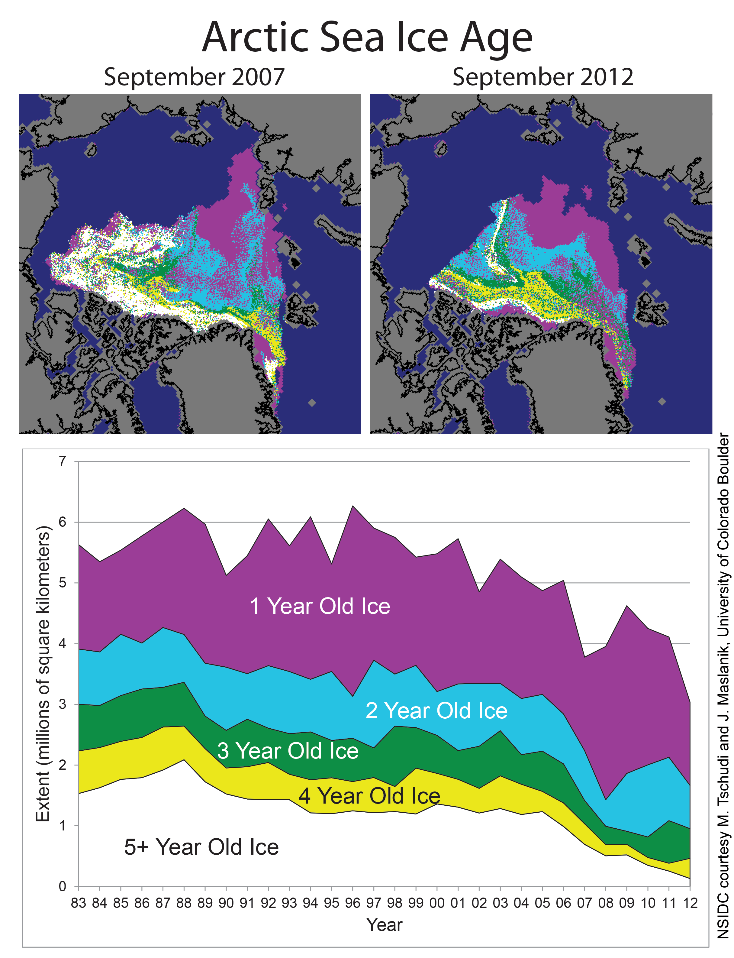
In the arctic much of the ice disappears every year (first year ice), but some remains (multiyear ice). The resilience of Arctic sea ice depends upon multi-year ice, because it's thicker. Most of the multiyear ice was lost in 2007 and has progressively depleted since then.
 As you can see, most of the remaining multi-year ice (about 20% of ice >=4 years) clings to the North Coast of Greenland and islands North of Canada and the thinking is that any ice that clings on beyond 2016 or so will be there. This might not happen. Here's why. There's regular arctic ice being churned out from the Fram Strait, the sea between Greenland and Svalbard thanks to Arctic ocean currents that head up North round from the Atlantic (the same currents that give the UK warm weather). You can see it here:

It's thought by some Arctic observers that the multi-year ice is held in place at the top of Greenland by what's called the Wedge. This may get swept out through the Fram strait in just a couple of days. It'd be the big Wedgie for the Arctic and would have serious consequences for the remaining multi-year ice and whether the Arctic sea ice would in fact trend to around 1MKm3 or nothing at all. Here's a model of the process:

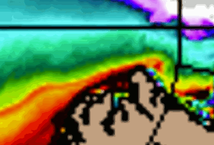
The reason why it can get swept out now, is because the ice is so thin elsewhere in the Arctic, on average, it's just over 1metre thick. Since we know that with thinner ice sea currents have more opportunity to influence Arctic sea ice and in recent weeks observers have noticed a number of cracks appearing in the Arctic sea ice, early than they would be expected (large cracks do occur in the ice, just not normally this early, here):
 (It's a false-color image so you can see the contrast more easily, Greenland is bottom right, cracks are shown white against orange).
Of course, it might not actually happen - I'll post a comment in a few days if it does!
One of the big predictions for forthcoming years is the collapse of the Arctic ice cap which may happen as soon as in just a few years. This graph makes it quite clear what will happen:

In the arctic much of the ice disappears every year (first year ice), but some remains (multiyear ice). The resilience of Arctic sea ice depends upon multi-year ice, because it's thicker. Most of the multiyear ice was lost in 2007 and has progressively depleted since then.

It's thought by some Arctic observers that the multi-year ice is held in place at the top of Greenland by what's called the Wedge. This may get swept out through the Fram strait in just a couple of days. It'd be the big Wedgie for the Arctic and would have serious consequences for the remaining multi-year ice and whether the Arctic sea ice would in fact trend to around 1MKm3 or nothing at all. Here's a model of the process:
The reason why it can get swept out now, is because the ice is so thin elsewhere in the Arctic, on average, it's just over 1metre thick. Since we know that with thinner ice sea currents have more opportunity to influence Arctic sea ice and in recent weeks observers have noticed a number of cracks appearing in the Arctic sea ice, early than they would be expected (large cracks do occur in the ice, just not normally this early, here):

Of course, it might not actually happen - I'll post a comment in a few days if it does!
Thursday, 13 September 2012
SIA Later!
Or rather we won't as in a few years it'll all be gone!
This is a little blog about current Arctic Sea Ice Area as we near the 2012 record-breaking summer minimum.
Take a look at the image:
 It's a section of the Arctic SIA as of yesterday.
We can see that the whole of the top-right hand edge, is the Northern Sea Route. You can see it's open-water and there's a lot of it. It first opened in 2009, but right now it's so wide you could pretty much sail the UK straight through; and within 3 years!
The opening of the Northern Sea Route means that ocean currents can sweep more easily round the eastern edge of the North Pole; bringing warmer waters from the Gulf Stream (not to be confused with the Jet Stream); and thus accelerating the collapse of the Arctic Sea Ice. We can see the effect quite clearly; the eastern edge continues to melt significantly, just days away from the supposed end of the melting season.
By contrast the Western edge of the Arctic Sea Ice is pinned by an extensive set of islands as well as the all-important Greenland land mass. This is why the Sea Ice is clinging to that edge, the frozen land keeps it cooler and protects it from ocean currents.
The last thing to note is the colour scheme. Red means '60%' ice, pink means '80%' ice; purple is near 100%. This means that the white dot in the middle, which is the North Pole itself, is only 80% Sea Ice at best and has a large amount of 60% (i.e. rotten) Sea Ice relatively close by. Given that the Eastern edge of the ice is about half-way to the North Pole, I'd guess it'll be gone within 3 years.
SIA Later, in a week or so for my post on the Arctic minimum!
This is a little blog about current Arctic Sea Ice Area as we near the 2012 record-breaking summer minimum.
Take a look at the image:
We can see that the whole of the top-right hand edge, is the Northern Sea Route. You can see it's open-water and there's a lot of it. It first opened in 2009, but right now it's so wide you could pretty much sail the UK straight through; and within 3 years!
The opening of the Northern Sea Route means that ocean currents can sweep more easily round the eastern edge of the North Pole; bringing warmer waters from the Gulf Stream (not to be confused with the Jet Stream); and thus accelerating the collapse of the Arctic Sea Ice. We can see the effect quite clearly; the eastern edge continues to melt significantly, just days away from the supposed end of the melting season.
By contrast the Western edge of the Arctic Sea Ice is pinned by an extensive set of islands as well as the all-important Greenland land mass. This is why the Sea Ice is clinging to that edge, the frozen land keeps it cooler and protects it from ocean currents.
The last thing to note is the colour scheme. Red means '60%' ice, pink means '80%' ice; purple is near 100%. This means that the white dot in the middle, which is the North Pole itself, is only 80% Sea Ice at best and has a large amount of 60% (i.e. rotten) Sea Ice relatively close by. Given that the Eastern edge of the ice is about half-way to the North Pole, I'd guess it'll be gone within 3 years.
SIA Later, in a week or so for my post on the Arctic minimum!
Subscribe to:
Posts (Atom)